Athens Digisonde
The Ionospheric Group of the National Observatory of Athens operates the Athens Digisonde [URSI code: AT138], one of the most advanced European real-time ionospheric stations, a Digisonde Portable Sounder – 4D (DPS-4D) at Penteli site (38oN, 23.5oE) since September 2000.

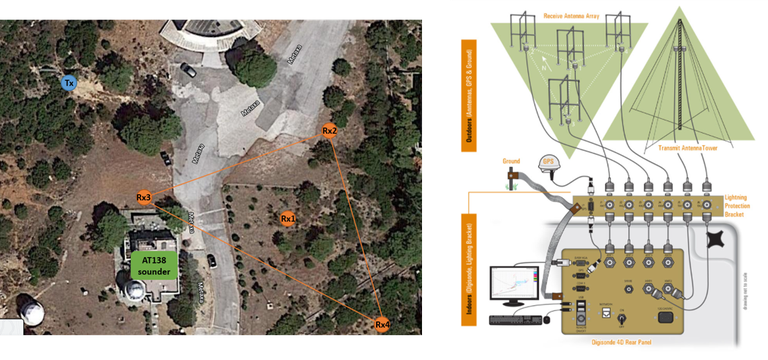
The Athens Digisonde site and the basic specifications of the sounder and receiving array are presented in the figures above. Detailed specifications of the Athens Digisonde hardware and software can be found in the web site of the manufacturer Lowell Digisonde International.
AT138 observations
The Athens Digisonde performs 5-minute scheduled observations with vertical incidence ionograms and ionospheric plasma drifts. The possibility to operate in bistatic link with other identical ionospheric stations (Digisonde to Digisonde – D2D) has been tested for the first time in the operation of the pilot network for Travelling Ionospheric Disturbances (TID) identification (Reinisch et al., 2019) and verified in the framework of the TechTIDE Horizon 2020 Project (Belehaki et al., 2021), funded by the European Commission from 2017 to 2019. Special campaigns for the collection of observations with higher cadence and performance of experiments with special settings can be requested in the framework of PITHIA-NRF Research Infrastructure Horizon 2020 TransNational Access (TNA) Programme.
The Athens Digisonde is part of the European ionosonde Network DIAS (European Digital upper Atmosphere Server) and part of the Global Network GIRO (Global Ionospheric Radio Observatory), operated by the University of Massachusetts Lowell. The Athens Digisonde observations support the European Ionospheric Service of the European Space Agency Space Situational Awareness Programme.
|
Access to real-time AT138 data |
 |
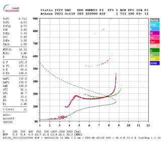
Short electromagnetic pulses in the frequency range between 1 and 20 MHz are vertically transmitted into the ionosphere and are received locally after their ionospheric reflection. From the ionospheric echoes received in the four DPS4D receiving antennas, their amplitude, travelling time (virtual reflection height), Doppler shift, polarization, angle of arrival and the electron density profile are derived. Vertical incidence ionograms display the virtual height (the range) of the HF waves. The ordinary waves echoes are marked in red, the extraordinary echoes in green. Other colors indicate off vertical echoes. The calculated electron density profile shows the real reflection heights of the ordinary wave. The topside profile is modeled assuming an α-Chapman profile with constant effective scale height. |
 |
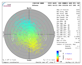
The transmitted signal illuminates a large area in the ionosphere, typically a few hundred kilometers in diameter. At the point where the local index of refraction becomes equal to zero, the sounding pulse is “reflected” from the ionosphere. If the normal to the surface of equal electron density contour points exactly towards the sounder, then the reflected signal returns to the sounder. Each such reflection point can be considered as a “source” of reflected signal. A map showing locations of all such “sources” is called a “skymap”. From the collection of the sources in the skymap the orientation of the normal vector characterizing the ionospheric tilt of an imaginary reflecting plane can be derived. In essence, this approach assumes a mirror type reflection of HF waves, a very simple model that neglects refraction from underlying layers and consider a flat Earth/ionosphere reflection geometry, which nonetheless can be efficiently used to characterize HF wave reflections from the ionosphere as long as magnetic field effects are not very strong. |
